Epilobium angustifolium subsp. angustifolium
fireweed
Onagraceae (Evening Primrose family)
Introduction to Vascular Plants
fireweed
Onagraceae (Evening Primrose family)
Introduction to Vascular Plants
Map
Distribution of Epilobium angustifolium subsp. angustifolium
Click here to view the full interactive map and legend
Illustration
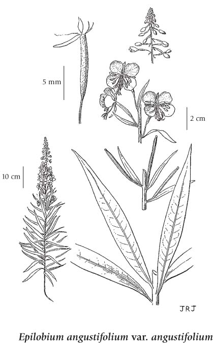
If more than one illustration is available for a species (e.g., separate illustrations were provided for two subspecies) then links to the separate images will be provided below. Note that individual subspecies or varietal illustrations are not always available.
Illustration Source: The Illustrated Flora of British Columbia
Ecology
Ecological Framework for Epilobium angustifolium ssp. angustifolium
The table below shows the species-specific information calculated from
original data (BEC database) provided by the BC Ministry of Forests and Range.
(Updated August, 2013)
The table below shows the species-specific information calculated from
original data (BEC database) provided by the BC Ministry of Forests and Range.
(Updated August, 2013)
| Site Information |
Value / Class |
||
|
Avg |
Min |
Max |
|
| Elevation
(metres) |
605 | 160 | 700 |
| Slope
Gradient (%) |
1 | 0 | 10 |
|
Aspect (degrees) |
144 | 145 | 145 |
| Soil
Moisture Regime (SMR) [0 - very xeric; 4 - mesic; 8 - hydric] |
6 | 4 | 7 |
| Modal
Nutrient Regime
Class |
C | ||
| #
of field plots species was recorded in: |
7 | ||
| Modal
BEC Zone Class |
SBS | ||
|
All BEC Zones (# of stations/zone) species was recorded in |
BWBS(1), SBS(6) | ||
|
Source:
Klinkenberg 2013
|
|||